

Desert Tortoise Presence / Absence Surveys: What Project Teams and Biologists Need to Know
A field-grounded guide to when a Mojave desert tortoise survey is triggered, which survey type your project needs, who is qualified to run it, and how the results shape your permitting path.
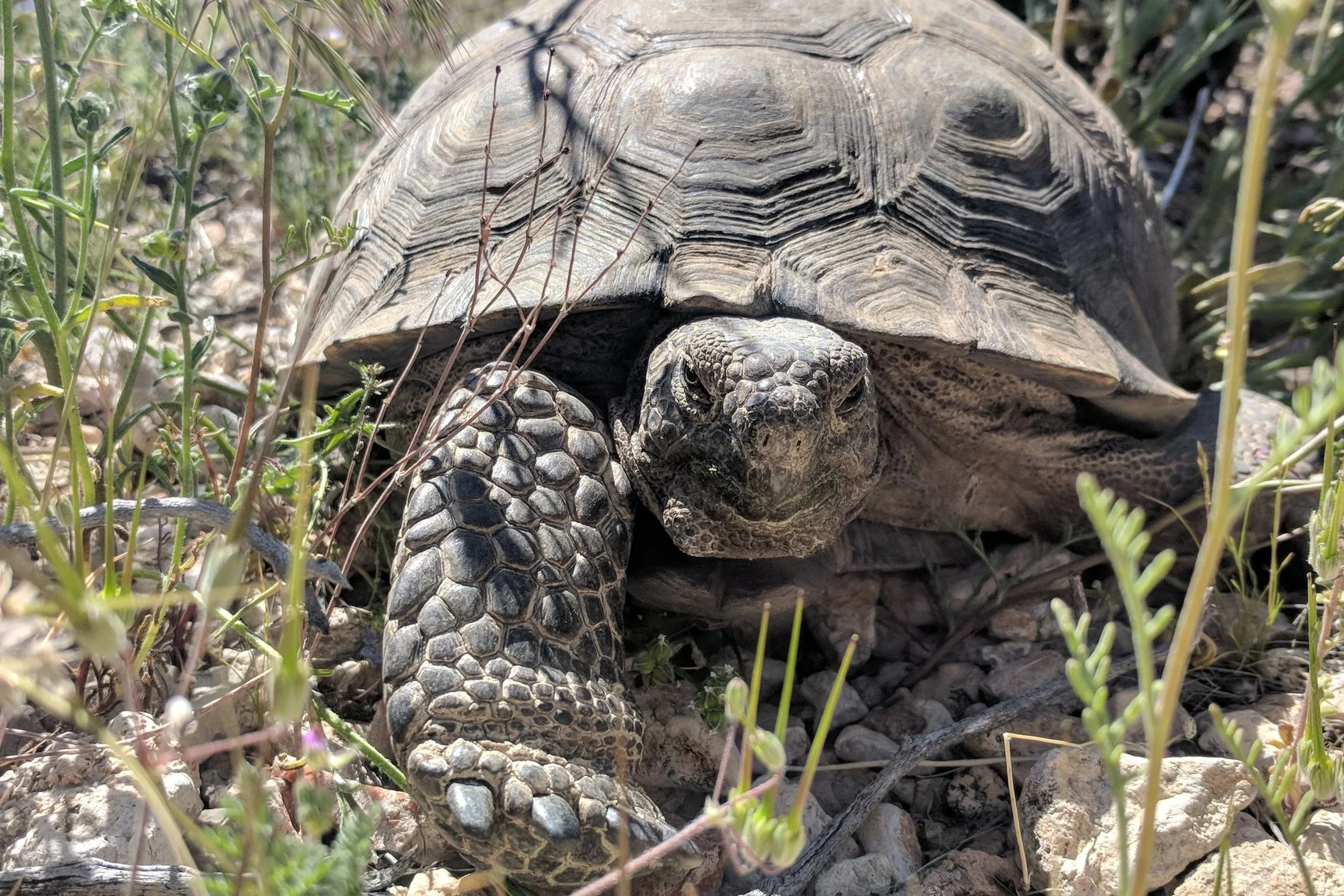
This three-part series walks a project from first look to final grading. Part 1 (this article) covers presence/absence surveys, the pre-project step that answers whether tortoises use your site. Part 2 covers clearance surveys, the 100 percent-coverage sweep done after fencing and right before ground disturbance. Part 3 covers construction monitoring, the on-the-ground compliance work that keeps a project inside its permit conditions.
Start here → Is your project in the Mojave desert tortoise range?
If your project sits within the range of the Mojave desert tortoise (Gopherus agassizii), a pre-project survey is very likely part of your path to approval, and it needs to happen before any grading, access work, or other ground disturbance begins. The USFWS defines the Mojave population as the tortoises north and west of the Colorado River in California, Nevada, Utah, and Arizona. Tortoises south and east of the river were reclassified as a separate species, G. morafkai. (USFWS 2019, Pre-project Survey Protocol)
The Mojave desert tortoise was listed as threatened under the federal Endangered Species Act on April 2, 1990, so any action within its range carries ESA obligations. Two quick checks tell you whether tortoise habitat is in play: the USFWS Mojave desert tortoise range map, and IPaC, the official Information Tool for Planning and Consultation (USFWS 2019).
Reach out when your footprint touches the Mojave Desert in Nevada, California, Utah, or Arizona and you are not sure whether tortoise habitat is present. A 10-minute range and IPaC check with us here at Desert Shield can save a season of schedule risk.
What a presence / absence does
On paper, the survey answers one question: are desert tortoises, or signs of tortoise use, present in the action area, and to what extent? In practice it does more than produce a yes or no. A well-run survey tells the project team where activity is concentrated, which parts of a design may need to shift, what level of biological monitoring construction will likely require, and how much lead time agency coordination will take (USFWS 2019).
Which projects trigger a survey
Any ground-disturbing action inside tortoise range can trigger a survey, and projects on federal land or with a federal nexus almost always do. The trigger is the potential to affect the species, not the size of the disturbance. Common project types include:
Solar, wind, and other renewable energy sites
Transmission lines, pipelines, fiber, and other linear corridors
Roads, interchanges, and public infrastructure
Defense and other federal projects on BLM or military land
Residential, commercial, and industrial development
Habitat restoration and reclamation work
Construction access roads, staging areas, and laydown yards
The legal driver depends on who is behind the project. Federal agencies that fund, authorize, or carry out an action must consult with USFWS under Section 7(a)(2) of the ESA. A private project with no federal nexus that is likely to result in take needs an incidental take permit under Section 10(a)(1)(B). Either way, survey data is crucial for educated permitting. (USFWS 2019)
The three pre-project survey types, and how to tell which one you need
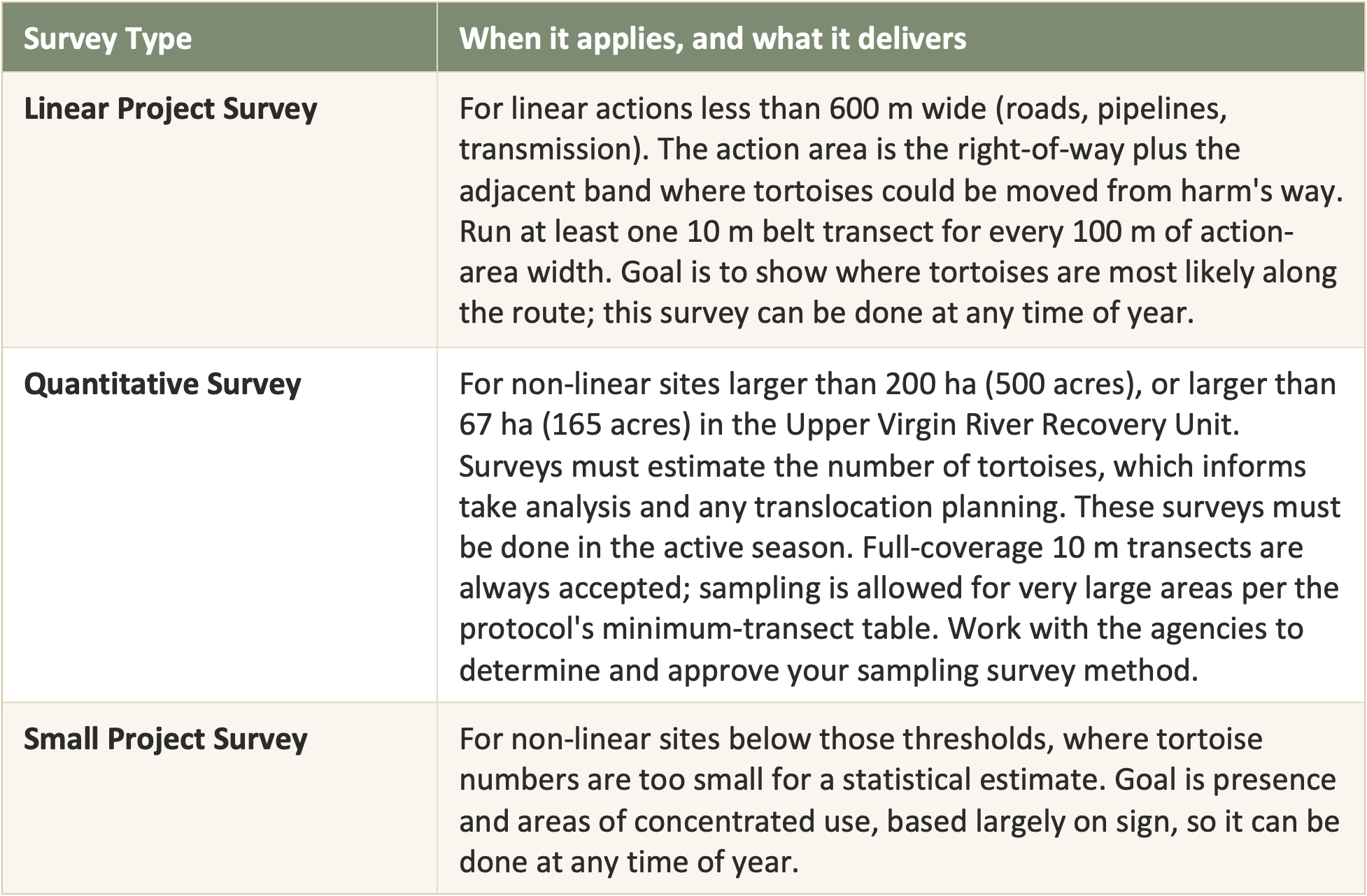
Note on abundance estimates: Quantitative estimates count tortoises at least 180 mm in midline carapace length and build in detection probabilities, including a rain-driven visibility factor, because tortoises spend much of their lives underground and even excellent surveyors miss tortoises. That is why the estimate is a modeled number, not a raw count. (USFWS 2019)
Qualified Surveyors
A pre-project presence/absence survey must be led by a USFWS Authorized Desert Tortoise Biologist (ADTB) along with qualified desert tortoise surveyors following the USFWS protocol. Because these surveys do not involve touching or moving animals, a federal handling permit is not required to complete them and they can often be considered “pedestrian surveys”. Using experienced surveyors is not just good practice: USFWS explicitly weighs surveyor experience when it decides how much confidence to place in the results (USFWS 2019).
The bar rises once a project moves into work covered by a biological opinion or an incidental take permit, which is where clearance, handling, and monitoring live (Blog parts 2 and 3). At that stage USFWS requires a USFWS-approved Authorized Biologist, and the relevant state wildlife agency must authorize anyone who handles tortoises. In California, CDFW must approve every individual who handles desert tortoises, including biological monitors and Authorized Biologists. Authorized Biologist qualifications forms should reach the USFWS or CDFW office 60 day before work starts to ensure a response in time. (USFWS 2009, Desert Tortoise Field Manual)
Need authorized desert tortoise biologists?
Desert Shield specializes in providing and staffing qualified desert tortoise surveyors and USFWS and CDFW approved Authorized Biologists across the Mojave Desert.
What surveyors look for
Because tortoises are cryptic and spend most of their time in burrows, sign is often more telling than a live animal. Surveyors walk the centerline of 10 m belt transects and record every indication of tortoise use, noting the location and the condition of each. The Field Manual is used to categorize sign condition, which helps agencies judge how recent and how reliable the evidence is. (USFWS 2019; USFWS 2009)
Live tortoises (recorded as above or below 180 mm, estimated without handling)
Active and inactive burrows and pallets (see class categories below)
Scat
Tracks
Carcasses and shell fragments
Courtship rings
Drinking depressions
Egg shell fragments and nest sign
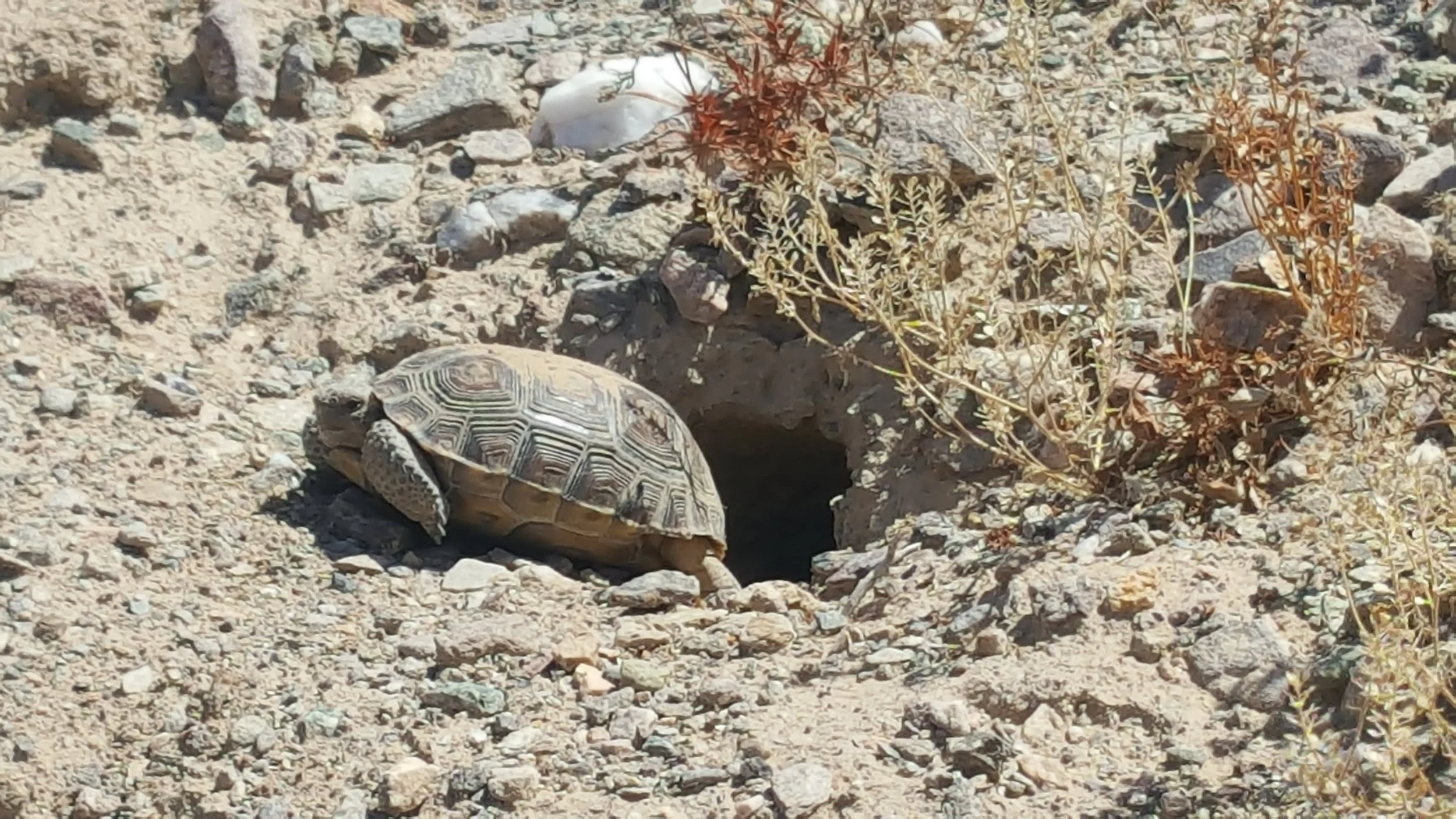
Burrow and Cover Site Condition Classes
Every burrow is recorded by condition class, along with whether it is occupied, any other sign present, and its GPS location. Because juvenile tortoises dig burrows that can resemble rodent holes, and tortoises also use burrows made by kit foxes and other animals, surveyors treat all burrows as occupied until proven otherwise.
The USFWS burrow classes are:
Class 1: Currently active, with a desert tortoise or recent desert tortoise sign.
Class 2: Good condition, definitely desert tortoise, with no evidence of recent use.
Class 3: Deteriorated condition, including collapsed burrows, definitely desert tortoise (describe in data form).
Class 4: Good condition, possibly desert tortoise (describe in data form).
Class 5: Deteriorated condition, including collapsed burrows, possibly desert tortoise (describe in data form).
NOTE: Classes 4 and 5 call for a written description because the burrow's origin is not certain. Photographing burrows and submitting the photos with the data sheets is recommended. (USFWS 2009, Desert Tortoise Field Manual)
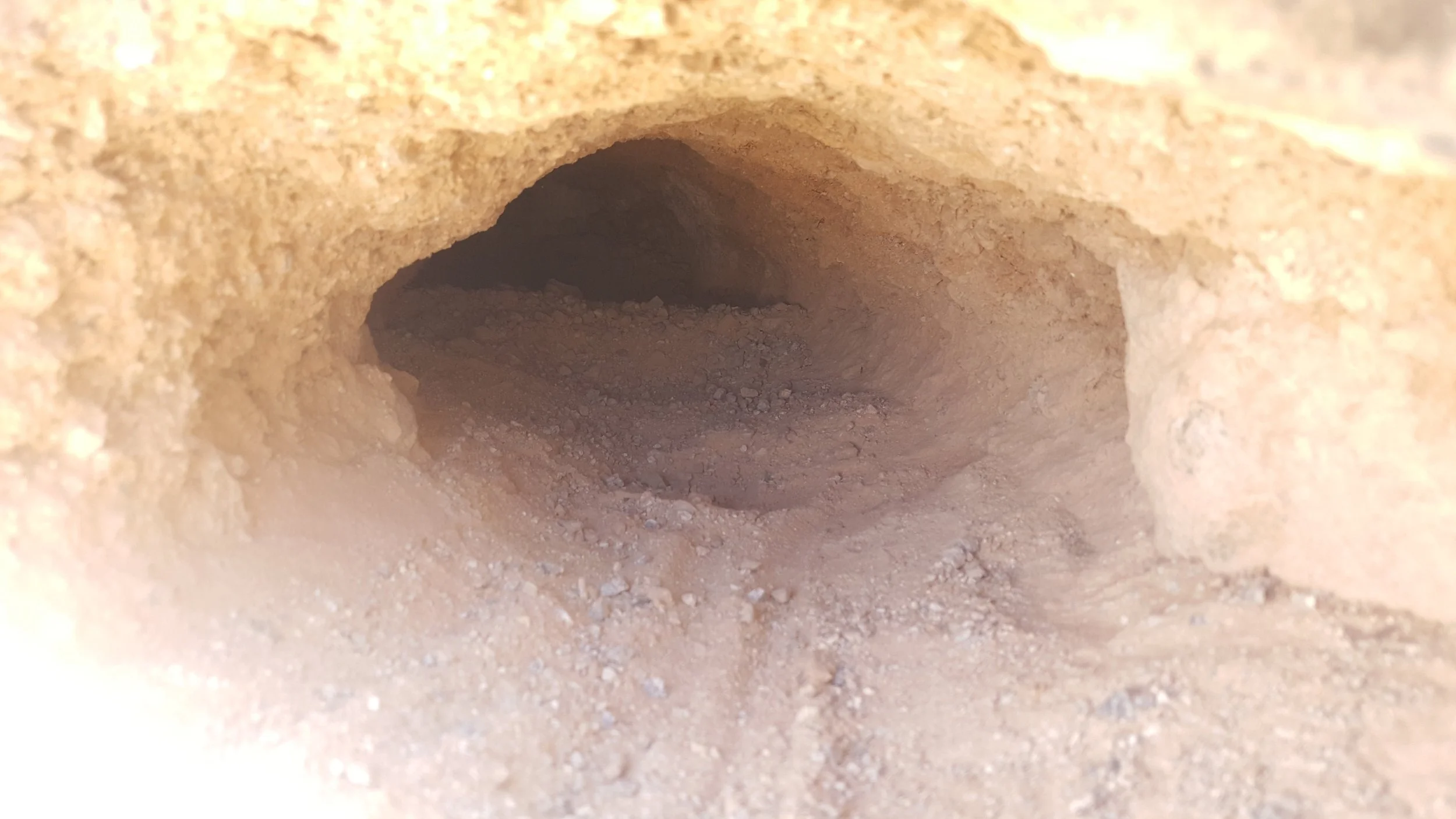
Example of a Class 1 or 2 Desert Tortoise Burrow depending on how obvious the tortoise tracks were in the field.
The pre-project survey process, step by step
The exact approach flexes with project size, habitat, and agency direction, but a pre-project survey generally runs like this:
Confirm the site falls within Mojave desert tortoise range using the USFWS range map and IPaC.
Define the full action area, not just the footprint (see the next section).
Coordinate early with the appropriate USFWS field office and state wildlife agency, especially where the site has agency-specific conditions.
Select the survey type from the decision key: Linear, Quantitative, or Small Project.
Plan timing around the survey type, tortoise activity, and weather, and build in agency review time.
Establish 10 m belt transects across the action area following the layout the protocol requires for that type.
Walk the transect centerlines, searching for live tortoises and sign.
Inspect each burrow with a hand-held mirror and/or light to check for an occupants, scat, tracks or other sign; a scope is not needed.
Record every observation with GPS location, transect data, date, time, air temperature, and sign condition.
Describe habitat conditions: plant communities, disturbance, elevation, soils, shelter sites, and raven or predator pressure.
Assemble the deliverables, data sheets, an action-area map showing all tortoises and sign, a habitat description, GIS and PDF spatial files, and for quantitative surveys the abundance spreadsheet, for agency review.
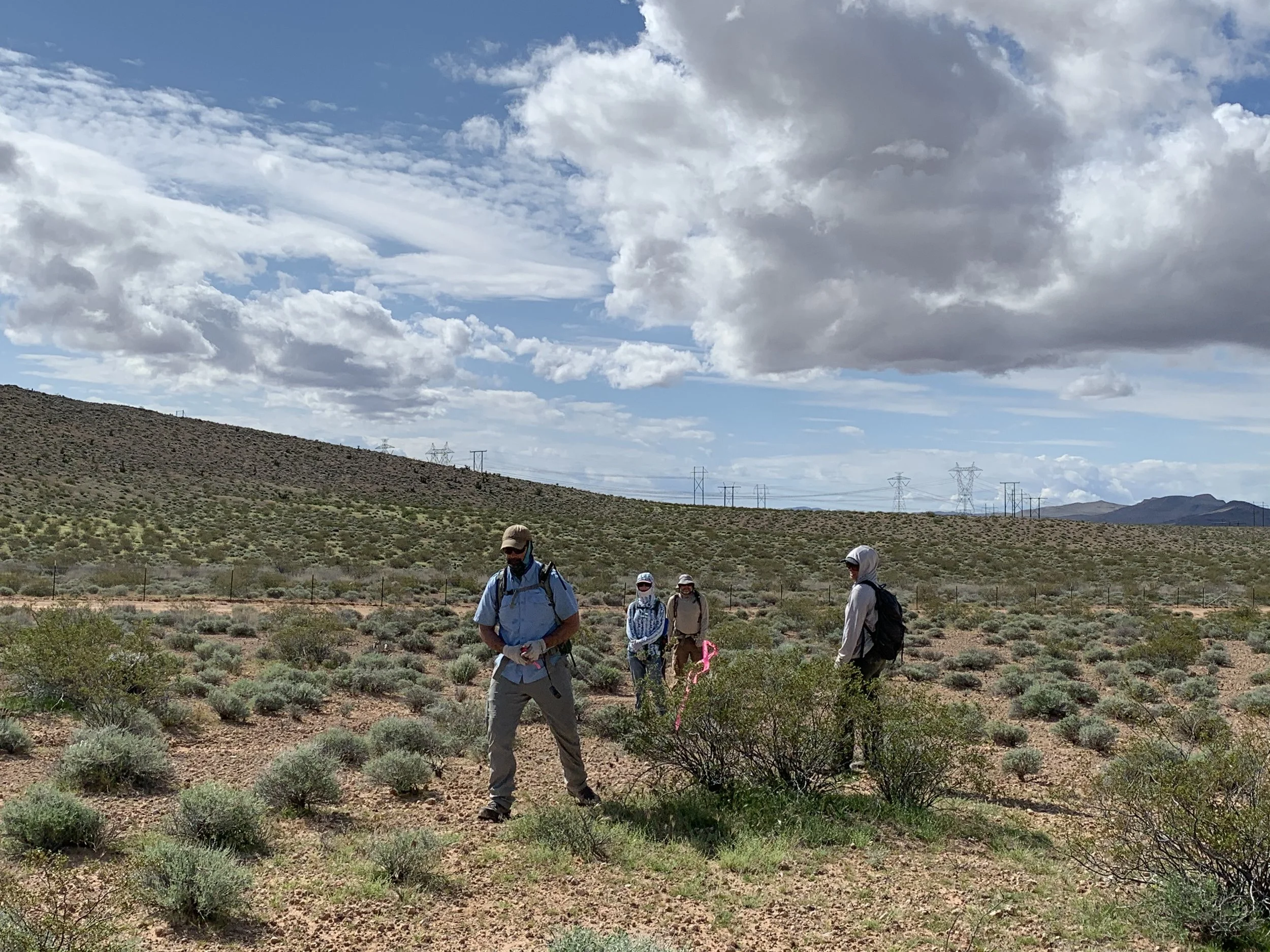
Survey the action area, not just the footprint
This is the most common mistake agencies see in the early project phase. The ESA defines the action area as all areas affected directly or indirectly by the action, not merely the immediate footprint (50 CFR 402.02). It routinely includes access routes and any area where tortoises would be moved during the work. The 2019 protocol retired the old 1992 zone-of-influence transects and replaced them with surveying the full action area because the footprint alone understates where the project reaches. If you cannot access part of the action area, survey what you can and document it in your report. (USFWS 2019)
The most common and costly mistake is surveying the footprint only. Define the action area with your USFWS field office when possible so the agency doesn’t send you back for additional survey after the fact causing delays and extra mobilization costs.
Timing and season
Quantitative surveys rely on counting active animals, so they must run in the active season: generally April and May, and September and October, when air temperature stays below 35 C (95 F). Air temperature is measured about 5 cm above the soil in full sun but in the observer's newly created shade. If site conditions show tortoises out earlier or later, request a variance from USFWS rather than surveying off-window without approval. (USFWS 2019)
Small Project and Linear surveys are different. Because they establish presence from sign rather than from a live count, the protocol allows them at any time of year, as long as conditions still let a surveyor detect sign.
Reach out when: Your construction date is set and you need a survey scheduled inside the active-season window, or you are weighing whether an off-season Small or Linear survey will hold up. The active season is short and books out fast in the Mojave. Lock timing early with Desert Shield.
How the results shape your project
Once complete, findings go to USFWS and the appropriate state agency for review. The biologist's job is to document the site clearly and defensibly: accurate sign records, honest habitat description, and enough supporting detail for the agency to make an informed call. The consultant does not set permit conditions. Agencies do, using the survey data. Depending on what the survey shows, results can drive:
Where tortoise activity is concentrated and which areas need closer review
Whether the design or access routes should shift to avoid impacts
Whether avoidance measures, exclusion fencing, or a translocation plan are needed
Whether biological monitoring is required during construction and to what extent
What a "no tortoises found" result really means
Finding no tortoises and no sign does not automatically mean none are present or that no measures are needed. Tortoises spend much of their time underground, and even trained surveyors miss animals. USFWS reviews a negative result against a full set of factors: habitat type and condition, location within the range, surveyor experience, timing, weather, the previous winter's rainfall, how much effort was spent, and whether the crew was focused on tortoises or scanning for many resources at once. This is why it’s important to documents effort, surveyor experience and conditions. (USFWS 2019)
Common mistakes that delay projects
Starting too late and missing the active-season window for a quantitative survey.
Surveying only the footprint instead of the full action area, including access routes.
Treating a quick habitat assessment as if it were a protocol-level survey.
Weak GPS data or unclear maps that the agency cannot verify.
Thin documentation of burrows, scat, tracks, or carcasses and their condition.
Using surveyors without the experience USFWS weighs when judging results.
Letting survey data age past a year without re-coordinating with USFWS.
Each of these can lead to a re-survey, a missed season, or an agency request that stalls project permitting.
What changes by state
Nevada. Coordinate with the USFWS Nevada Fish and Wildlife Office in Las Vegas, along with NDOW, BLM, and, in the Las Vegas Valley, the Clark County Desert Conservation Program, depending on land ownership. On BLM and other public land, survey scope, fencing, worker training, clearance, monitoring, and reporting are often written into the project's biological opinion, right-of-way grant, or permit conditions. Anyone handling or moving tortoises must hold the correct federal and state authorization before work begins. (USFWS 2009; USFWS 2019)
California. The Mojave desert tortoise is protected under both federal law and the California Endangered Species Act, so you must coordinate with CDFW in addition to USFWS. If a project may result in take, a CESA Incidental Take Permit through CDFW may be required, and CDFW recognizes the USFWS pre-project protocol as its recommended survey method. CDFW must approve every person who handles or monitors tortoises under the permit. Work that affects washes or other drainages can also trigger a Lake or Streambed Alteration Agreement. Exact requirements depend on site, habitat, permits and jurisdiction. (USFWS 2009; CDFW)
Arizona. In Arizona, the Mojave desert tortoise occupies only the land north and west of the Colorado River, largely the Arizona Strip and the country around Lake Mead. Everything south and east of the river is the Sonoran desert tortoise (Gopherus morafkai), a different species with its own survey expectations, so confirming which side of the river you are on is the first step. For Mojave tortoise projects, coordinate with the USFWS Arizona Ecological Services Office in Flagstaff and the Arizona Game and Fish Department (AZGFD). Anyone who handles or moves tortoises must hold the appropriate federal authorization and AZGFD authorization before work begins. (USFWS 2019; USFWS 2009)
Utah. Utah is where the survey math changes. The Upper Virgin River Recovery Unit, east of the Virgin River in Washington County, uses a lower size threshold for quantitative surveys: 67 ha (165 acres), compared with 200 ha (500 acres) across the rest of the range. That means a mid-sized site that would qualify as a Small Project elsewhere may require a full quantitative survey here. Much of this area also falls within the Red Cliffs Desert Reserve and the Washington County Habitat Conservation Plan, which can add their own review and permit conditions. Coordinate with the USFWS Utah Ecological Services Field Office and the Utah Division of Wildlife Resources (UDWR), and confirm state handling authorization before any tortoise is touched or moved. (USFWS 2019; USFWS 2009)
Why local experience matters. A team that already knows the field offices, their expectations, and their reporting formats can plan timing, staffing, and documentation correctly the first time, helping insure a fast and clean review from the agencies rather than a repeated one.
Coming next in this series
Once a project is authorized and about to break ground, clearance surveys remove tortoises from harm's way. Part 2 will cover:
What clearance surveys are for: locate and remove every tortoise in the project area, and safely handle any eggs, per the Field Manual.
When they are required: occupied habitat, typically as a Term and Condition of a biological opinion or incidental take permit.
Timing: immediately before surface disturbance, or after a tortoise-proof fence is installed so animals cannot re-enter.
Method: 100 percent coverage, at least two consecutive passes on transects no wider than 5 m (15 ft), in the active season, with a possible third pass if a tortoise is found on the second.
Handling rules: work below 95 F (35 C), keep animals shaded, and follow burrow-excavation and nest-and-egg protocols.
Translocation basics and the role of a USFWS-approved translocation plan.
Tracking of relocated animals
Reporting: area cleared and number of tortoises found, reported to USFWS and the state agency in writing within one week.
Success rates of translocations and predator surveys.
Planning your budget
With the site cleared, monitoring keeps the project compliant through the build. Part 3 will cover:
The biological monitor's role and daily responsibilities under a biological opinion or permit.
Worker environmental awareness training and why it protects both the tortoise and the schedule. Key tortoise facts construction workers love to hear during weap to make it more engaging.
Installing and inspecting tortoise-proof exclusion fencing.
Routine safeguards: under-vehicle checks, speed limits, and controlling trash and spills that subsidize ravens.
What to do when a tortoise appears inside a cleared or fenced area: halt work and follow the response protocol.
Documenting take, noncompliance, and incident reporting the agencies expect.
Work with the Mojave desert tortoise specialists
Desert Shield Environmental Professionals supports project teams across Nevada, California, Arizona, Utah, and the wider Desert Southwest, with a home base in the Las Vegas and California Mojave. We provide qualified, experienced field staff for:
Mojave desert tortoise pre-project and presence/absence surveys
Habitat assessments, sign documentation, and action-area mapping
Survey maps, GPS data, GIS deliverables, and agency-ready reporting
Clearance survey support and USFWS-approved Authorized Biologists
Biological and construction monitoring and worker awareness training
Agency coordination and compliance planning with USFWS, CDFW, NDOW, BLM, and Clark County
The earlier we are involved, the more schedule and budget risk we take off the table. If your project may touch tortoise habitat, talk to us before field work or construction begins. Contact Desert Shield now!
